

I had hoped to finish hiking the PCT this year, completing a journey begun in 2013. I would start from where I left off at Elk Lake in central Oregon last year and proceed to the Canadian border, about 750 miles. But the more I thought about it, the less it seemed like a good idea. There were two problems: trail closure and border closure.
The Lionshead Fire of 2020 left a 20-mile stretch of the PCT closed*. 20 miles is not that big a stretch to miss. But there were no plausible hiking detours that I could take. I would have to hitch or arrange a ride to get around the closure. And the nearest highways crossing the PCT south and north of the closure are 120 miles apart. That meant skipping a major portion of Oregon, including the Mt Jefferson Wilderness, which I very much wanted to see.
Added to that, Canada is still not letting PCT hikers enter the country by trail. This means that hikers have to turn around and hike 40 miles or so back to the nearest highway.
So I planned out a couple of 100-mile hikes in the Sawtooths of Idaho and the Wind Rivers of Wyoming. I have never hiked Idaho, and haven’t hiked the Wind Rivers since the mid-1980s. There would be great scenery and plenty of fishing in alpine lakes. Also there would be actual trails. After my last section hike of the Desert Trail (which has very little trail), I was looking for trips with less-challenging hiking and route-finding. I wanted to walk, not scramble and thrash.
But a few days before I intended to hop in the car and drive to Idaho, my wife Cathy and I were listening to the radio on the way home from a dayhike in the Indian Peaks Wilderness. The governor was being interviewed and was talking about how the state of Colorado had expanded bus service to west slope towns like Steamboat Springs, Durango and Crested Butte. Fares had been cut in half to encourage ridership.
“That’s what you should do” Cathy said, “take the bus to Crested Butte and walk home. It would be a no-driving low-carbon adventure.”
She was right. It would be very cool to take the bus to CB and then walk home, or at least walk to Nederland near the Indian Peaks Wilderness, where I could take the bus back to downtown Boulder. No burning up 60-70 gallons of gas (and thus emitting >1500 pounds of CO2) driving across Wyoming and much of Idaho.
As soon as we got home I opened up GaiaGPS and began plotting out a route. A plausible one soon emerged: Crested Butte to Marble, Marble to Aspen (where I could resupply), Aspen to Frisco (another resupply), Frisco to Nederland via the CDT alternate route. There would be several roadwalks to connect trails, but none more than a few miles. There would also be a cross-country stretch over the divide which separates the Fryingpan River basin from the Eagle River drainage in the Holy Cross Wilderness. That wasn’t ideal–my goal for summer hiking was to follow established trails–but it was manageable.
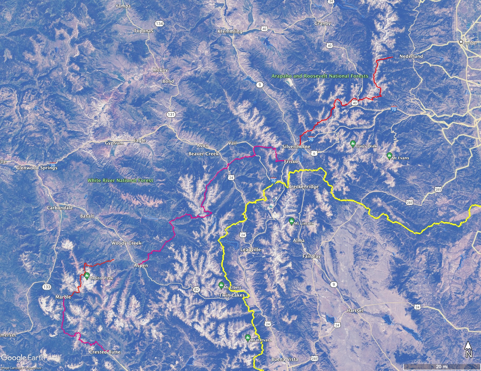
Google Earth image of my intended route (in red) from Crested Butte to Marble, to Aspen (resupply), to Frisco (another resupply) to Nederland west of Boulder. The gaps are where I planned to take shuttle buses. The yellow trace is the Colorado Trail. Click to enlarge.
On the other hand, the route would be steep. Over its roughly 195 miles, there is about 54,000 feet of elevation gain, an average of 280 feet per mile. That’s a lot of climbing. By comparison, the Colorado Trail averages 180 feet per mile, as does the High Sierra portion of the PCT. Rather than follow a high route, as those trails do, I would repeatedly be hopping between basins, going from 12,000 foot passes down to 7500 foot river valleys. And then back up again. And again.
But I had fallen in love with the hike concept, and also (as usual) could not resist a challenge. I could do this trip now. No telling if I could do it next year or the the year after that or the year after that. The opportunity was there and so it was time to take it.
To cope with the climbs I would dial back my usual pace of 20+ miles a day to 15. That’s still about 4200 feet per day of climbing, more than I would prefer, but not enough to kill the trip. If all went well I would arrive back home on August 23, just in time to leave the next day for a packraft trip on the Rio Chama that we had a permit for. I packed resupply boxes, made a reservation at the hostel in Crested Butte and was ready to go.
Cathy dropped me off the next day at the downtown Boulder station. I took the Flatirons Flyer to Denver’s Union Station, boarded the Bustang for Crested Butte and was on my way.
*The Lionshead closure was lifted August 15