
Back to the PCT after having hiked the AZT in 2017. My plan was to go from Lake Tahoe, where I left off in 2016, to Ashland, OR, thus knocking off the rest of California. I intended to start July 20th or so and end up in Oregon by the end of August.
But a friend that I introduced to hiking was psyched to do more of the Colorado Trail, and I love the Colorado Trail, so we hiked from Copper Mountain to Monarch Pass, about 150 miles, in late June and early July. You can read my journal entries for this trip starting here.
Unfortunately this time period covered both my anniversary and my wife’s birthday, and certainly did not win me any spousal approval points for long distance hiking. In fact, as soon as I got back, she declared that she would be going on a trip of her own and spent the second half of July visiting Washington DC and NYC with her sister. So much for my planned start on the PCT in July.
I committed to leading a backpack trip for the Sierra Club’s ICO program over Labor Day, so I couldn’t just push my itinerary back. And I’m not a strong enough hiker to cover 660 miles in 3+ weeks. So I had to accept the inevitable, dial back my plans, and just be glad that I was going. Long-distance hiking always requires a willingness to change plans as circumstances change, and this was no different. Rather than hiking 660 miles Tahoe-Ashland, I would hike 410 miles Tahoe-Shasta.
Northern California rarely tops anyone’s list of favorite sections of the PCT. It’s hot by July and August, often dry, much of the hiking is through second- and third-growth forests. It comes right after the High Sierra, one of the most scenic hikes anywhere in the world, and suffers from the comparison. And now, in our warming climate, it is especially prone to wildfires.
The smoke was an almost constant companion, even before I started walking. I could see the smoke from the Carr fire as I flew into San Jose, and found South Lake Tahoe pretty well blanketed when I stepped off the shuttle. There were a few days when the wind shifted and the air cleared, but they were a minority.
Far too often I found myself hiking a ridge in a smoke cocoon that limited my world view to a mile or two – ghostly ridges fading in and out, never really present, more a notion than a landscape. Worse was the sickly orange light filtering through the forests, the smell of smoke and the sense of doom pervasive and inescapable. I suspect a lot of hikers bailed on this stretch and hitched north to escape the smoke and I can’t blame them. I worry that thru-hiking the PCT in one season may soon become impractical – that skipping sections to avoid smoke and fire will be the new normal.
But I did hike this section and tried to make the best of it. Some days were good, and others not and I tried to be honest about that in my journal.
I tried recording some songs on trail for the slideshow, as I had for the AZT. But I wasn’t very successful. Some days the smoke left my voice thin and hoarse and I couldn’t make it through a song without coughing. Others just left me without the energy needed to play music like I meant it. And other days I had that energy but wanted to enjoy it in the moment and not dig out a microphone. So be it.
Gear List
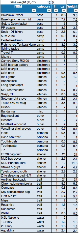
I sent back my Ursack and fishing gear from Chester, reducing my base weight to 11 lb 11 oz. The Chromedome umbrella was definitely worth its weight, making hot steep climbs much more bearable.